Thursday, October 10, 2013

Stone walls

This month I have written a column about stone walls. Seeing the new walls under construction this summer at Conifer Hill prompted me to consider the old walls that were there in my childhood.

There's quite an art to building attractive stone walls from such irregularly-shaped rocks. I like the resulting texture and I marvel at the relatively flat top surface.
Across the street from Conifer Hill Commons is another stone wall, this one closer in size and style to the ones I recall. It borders the office park, but a slight squint of my eye can transform it into the old wall running --in exactly the same location-- by Granddaddy's garage and the wooded path leading ahead to our back yard.  I almost expect to be able to climb over this wall, walk between the trees and building shown here, and proceed to the little house where I lived for my first 14 years.
Gazing at this wall, at this angle, I can picture the trapeze my father hung on one tree inside the wall, not far from the office where my mother and father worked. They had converted Granddaddy's garage into a small factory for making hearing aids. This was the location of the beginning of Nichols & Clark, Inc., makers of UNEX hearing aids. I played outside while they worked. Around behind the little building, on the side towards our garden, was space for horse-shoes, a game enjoyed by some of the Nichols and Clark employees at break time.  (In my August column I wrote of playing with carbon paper and adding blue markings to a white garage door; that mischief happened here.) 

Are there any photos of the old stone walls of my childhood? I've been looking through photo albums and piles of loose prints. No one wasted precious photographic film on walls, I guess. The best I could find were some photos of us with glimpses of wall in the background, often out of focus, naturally. I intend to scan a few examples and post them. Stay tuned...  
[Update 5/9/14: I've posted some old photos of stone walls in an entry titled "Signs of spring and old memories."]

Meanwhile, I have found an interesting webpage about the history of stone walls in New England:

Monday, September 2, 2013

Enlarged map

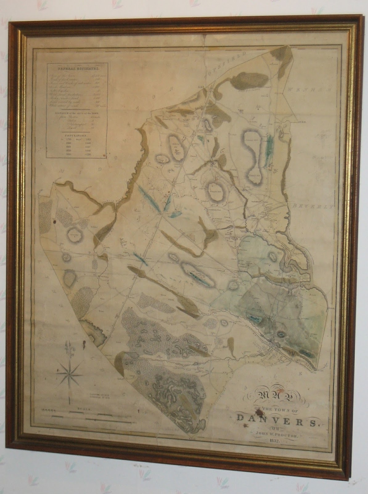
One of my relatives has asked for a larger view of the 1832 map of Danvers. (See previous post.) I've taken a new photo today, which I've attempted to post here in the largest size.  But the blogger software limits the size that can be displayed, unfortunately.   See below for alternatives.


I have now posted two larger images on another server:
For better quality images, I would need to use a better camera or, ideally, to remove the fragile map from its frame and have it scanned on a large flat-bed scanner, or take it to a professional to do the job. A project for another day...

Fortunately the Danvers Archival Center has copies of this published map.  And the Norman B. Leventhal Map & Education Center at the Boston Public Library has a copy that is viewable online:
You can zoom in to focus on details.  Very nice!    [viewed 9/21/21]


Wednesday, August 28, 2013

1832 Danvers map

Here's a closeup of an old Danvers map that hangs on my wall.  The date on the printed map is 1832. The pencil annotations are undated, but most likely were added by my great-grandfather Andrew Nichols, a surveyor and civil engineer who in 1861 built a cottage at 98 Preston Street and raised his family there.  He lived until 1921.

This image helped me as I wrote the ending of my previous post --describing where Nichols Street used to run.

Compare this image with the photos in my previous post.  The straight road running from SW to NE is the Newburyport Turnpike (Route 1).  The CVS now at the corner of Rte 1 and Conifer Hill Drive sits right where the home of "J.Nichols" is marked on this map.  That was the farm house of Andrew's uncle and aunt, with whom he lived and for whom he worked as a young man.

Dale's Hill is drawn to the right -- resembling a fuzzy caterpillar. Just south of that hill another "Nichols" home is marked, and an "Elm Tree." There was a huge elm near the entrance gate to the Locust Lawn estate.  (See old photo I posted in March).


Here is a view of the 1832 map as it hangs in my home.  Click on the image to enlarge it. (Or see the links in my next blog entry.)


The map was made by John W. Proctor, 1832.


The upper left corner of the map includes a panel titled General Estimates:

Area of the Town .........17,112 acres
Ponds of fresh water           166 acres
Rivers and creeks of salt water ....... 300 acres
Fresh meadows ....1,200
Salt marshes....    50
Wood Land (productive)...    3,000
Rocky (waste) Land ...       4,000
Land covered by roads ...    480
Whole extent of roads ...      80 miles.
   -------------------------------------------

Population:

1783, Sept   1,921
1800      2,643
1810      3,127
1820      3,646
1830      4,228